
Western Victorian walks
There's only one walk in this section so far. More will be added.
I only write descriptions of good walks that aren't in reliable guidebooks. There are plenty of great walks in western Victoria, not just in the Grampians but also in the Mount Cole Range, the area west Portland and plenty of other places.
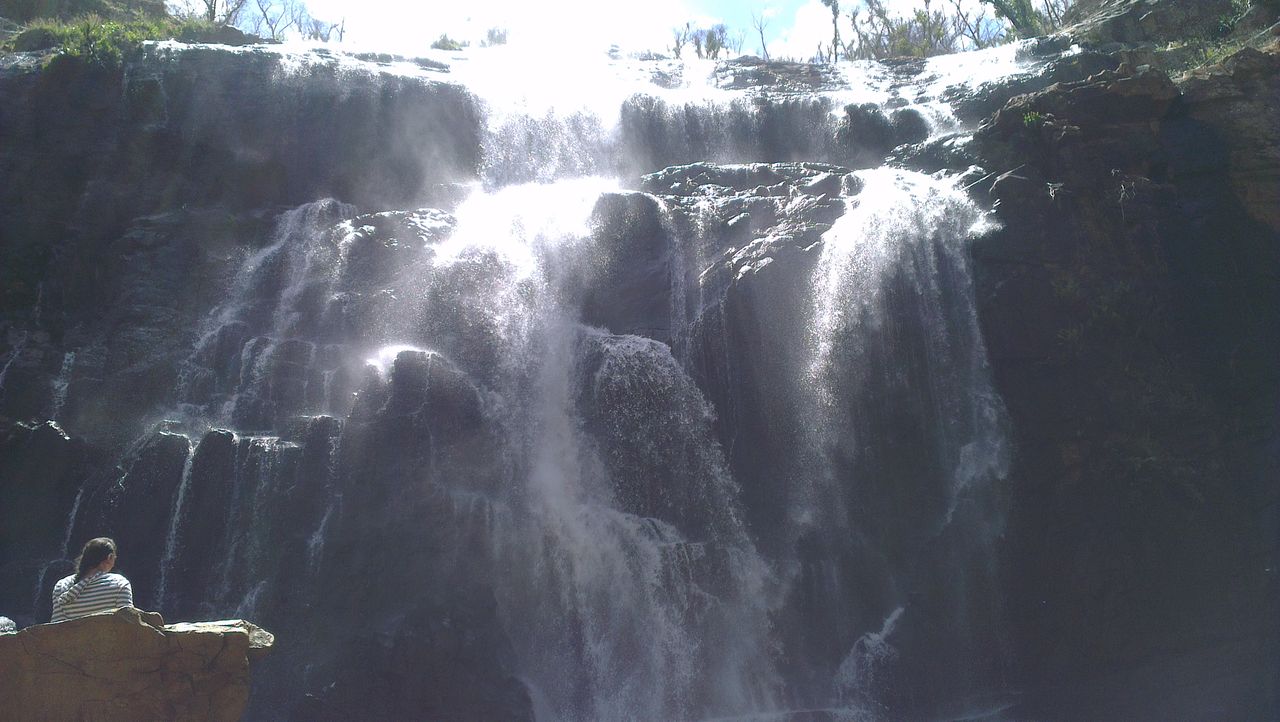
MacKenzie Falls. Photo: © David Sisson, 2014.
MACKENZIE FALLS CIRCUIT, THE GRAMPIANS
© David Sisson 2014.
When I was designing a walks programme for a 2014 Hiking! tour of the Grampians, I was unsure what to do with the easy group on the day the medium and hard groups did walks in the Mt Rosea area. Fortuitously, Parks Vic reopened tracks in the MacKenzie Falls area after they had been closed for years due to flood and later fire damage. The walk in the gorge from Zumstein's to MacKenzie Falls is well known for it's spectacular scenery, but preferring a circuit, I searched maps for a return route and spotted an old 4WD track to the north. It didn't look too steep, but we were quite prepared to alter the proposed route and return by the river if it was overgrown or looked too hard. However the walk worked out perfectly and it's one of the more enjoyable and scenic easier walks I've ever done.
Time, distance, grade and season. The walk is 9½ km long and should take most groups about 4 hours. All of the walk is on well built tracks. With a couple of staircases over rocky sections, it's a fairly relaxed walk with no extended uphill sections apart from the very long staircase next to MacKenzie Falls. The less visited route along the ridge to the north isn't at all challenging. While not a super easy walk, it shouldn't present any problems for groups who have done half day walks before.
The Wimmera district of Victoria can be punishingly hot in summer, so I would not recommend visiting from December to March. The waterfalls are at their best when there is plenty of water flowing over them, so the walk is best done in winter or spring, although releases of water for irrigation from nearby Lake Wartook ensure there is a decent flow of water all year round.
Access. Drive to the tourist town of Halls Gap in the centre of the Grampians. At the road junction just north of the shopping centre, head west along Mount Victory Road, C 222. At first the road twists and turns as it ascends the range, but it soon settles down to a gently winding road heading generally north west. Drive past the MacKenzie Falls car park and turn off the main road to park at Zumstein's, 21 km from Halls Gap.
The walk. Start the walk by crossing the MacKenzie River on a bridge and then head up stream. Soon another bridge is crossed and the wide valley slowly begins to turn into a gorge. The track is generally not too high above the river and gently ascends for a few kilometres until Fish Falls is reached. Over several drops, the water falls 30 metres and Fish Falls has a much more relaxed and less crowded atmosphere than the falls just upstream. Take a break half way up the falls on the rocky platform beside the staircase before continuing.
By now you are definitely in a gorge and while the track is excellent, there are a few short sections where a little rock hopping is required. Before long you will round a corner and notice two things. Firstly the 40 metre high MacKenzie Falls (which are much higher and more impressive than they appear to be in photos), and secondly (unless you visit at at a particularly quiet time) the crowds of people, which can come as a bit of a shock after you have spent a couple of quiet hours walking up the valley.
After you have taken a few photos, head up the long staircase which climbs about 100 metres up to Cranage's car park. At the car park head towards the toilet block and looking north, you will see a fire break with a gravel road in the middle that heads up a fairly gentle hill. Take your time on this 1 km stretch, there is no false summit, so you will have a good idea of your progress. Looking north from the hilltop, the roads descends for a few hundred metres to a minor dip before ascending to an apparent road junction. At the dip you will see a road branching off to to the west, turn on to it and walk along the road. (The road that heads west further up the hill is only a couple of hundred metres long and leads to a power pole.)
The final section of the walk is quite different, it heads west near a minor power line along a scenic ridge through increasingly open woodland with abundant wild flowers in spring. Half way along, near the two tight bends, there are a couple of 20 metre sections where the track almost becomes steep, before it continues it's gentle descent towards Zumsteins. The ridge provides a unique view of Asses Ears and the two rocks sticking up from the summit leave you in no doubt how the mountain got it's name. 300 metres from Zumsteins you have a choice, you can either take a steep short cut down a fire break directly to the pedestrian bridge and the car park or you can stay on the more leisurely track as it swings around the hill to the same destination.
Variations. There isn't much scope for varying this walk, although the short side trip from Cranages car park to view Broken Falls is worthwhile, as is the longer path leading to the viewing platform north of MacKenzie Falls. Both side trips are well signposted and are shown on the map by yellow dots.
While you could start the walk at MacKenzie Falls, you would lose the feeling of a growing awareness of being in a scenic gorge and the mystery of discovering the falls that you get stating from Zumstein's. It's best to do the walk in an anti-clockwise direction as while descending the ridge road is quite pleasant, it would be more difficult walking up it.
© David Sisson 17:43, 11 November 2014.

Map of the walk, the route is shown in blue. Scale: 1:25,000 (4 cm = 1 km.)
View counter. The number includes views of an earlier version of this page that was on wikiski.com