

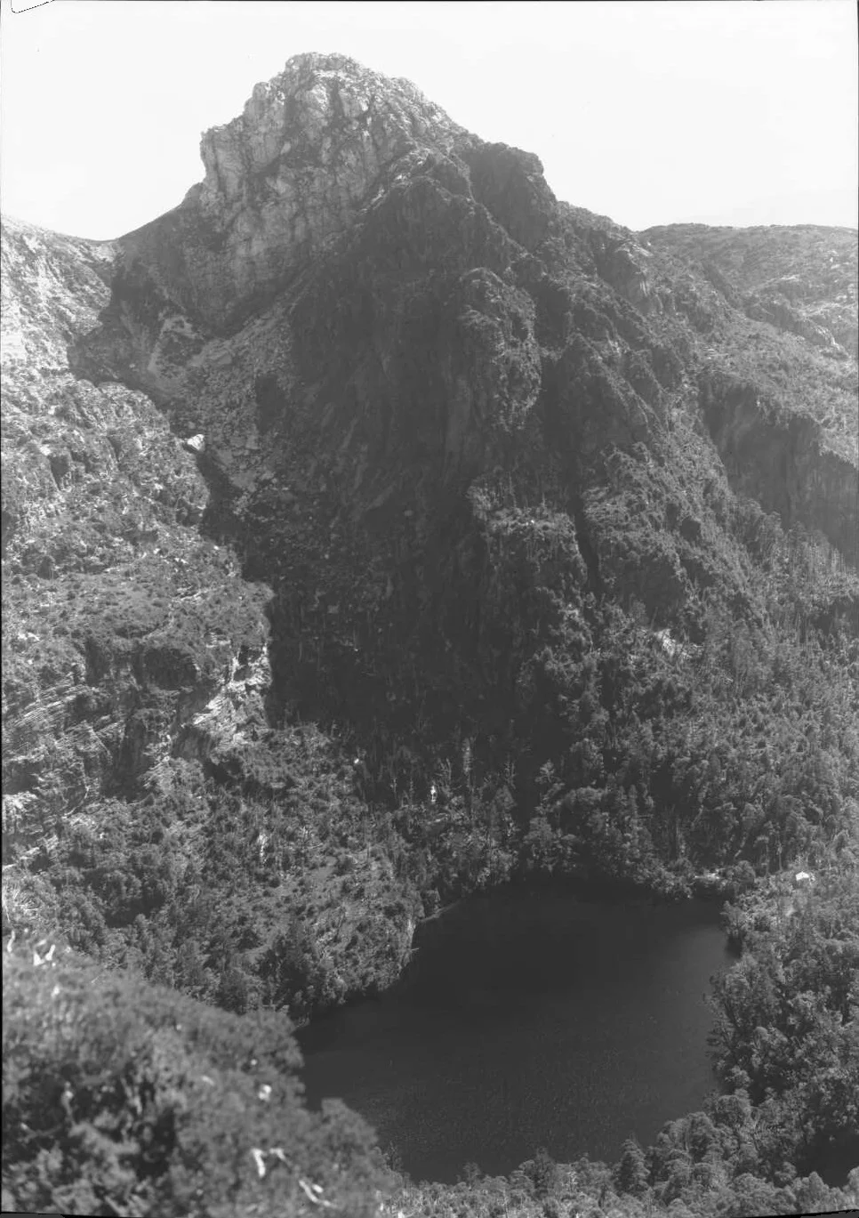
Third Lake Tahune Hut from the base of Frenchmans Cap cliffs. From Green Design site
South West Tasmanian hut histories
In the early years of this century I wrote a couple of dozen short histories of huts in Victoria and Tasmania for the Kosciusko Huts Association. While their huts directory is still a useful resource, the histories are not being updated. So here are updated and expanded versions of three short articles I wrote on western Tasmanian Huts that originally appeared in the KHA Huts Directory, plus a new section on the three sided shelters erected in the south west around 1960. If you are interested in looking after Tasmanian huts, consider supporting the Mountain Huts Preservation Society. David Sisson, June 2018.
Locations of the 11 buildings at Melaleuca
Contents
Lake Tahune Huts at Frenchmans Cap
Third hut. 2018 - present
Second hut. 1971 - 2018
First hut. 1947 - 1966
Lake Vera Huts
Three sided shelters (Section under development.)
Transportable track builders hut (aka. High Moor Hut.)
This page only covers huts that have not been written about elsewhere. Other remote huts in the south west (with links to other websites) are:
High Camp Hut on Mt Anne.
Eleven huts at Melaleuca, including Charles King Memorial Hut and a second hut for walkers.
Clyde and Wyn Claytons house at Claytons Corner on Barthurst Harbour.
Edwardsens Hut. An old miners hut near Point Eric on Cox Bight, collapsed in the 1990s.
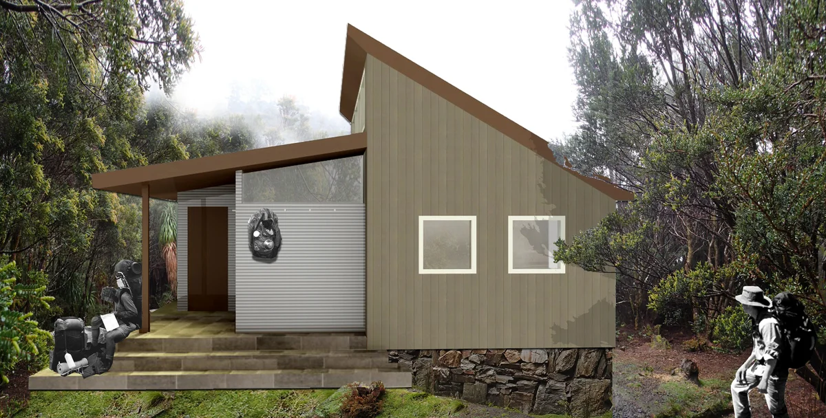
A proposal for the third Tahune hut. Floorplan on the architects website.
Lake Tahune Huts
© David Sisson. 2005, updated 2015, 2017, 2018.
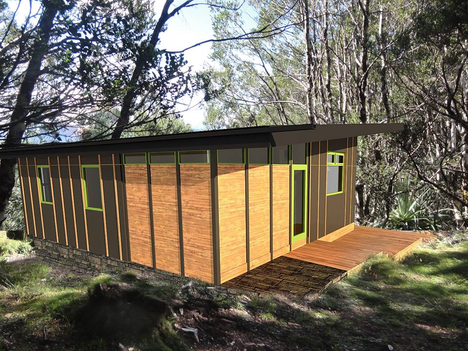
Another proposed design for Tahune Hut in PWS May 2016 Facebook post.
Three huts have been built on a site at 965 metres altitude on the north east shore of Lake Tahune under the cliffs of Frenchman's Cap in western Tasmania. The site overlooks the Franklin River valley. In good weather the location has arguably the most spectacular view of any hut in the country. Grid: 039 198. What3words ///spider.ransom.portion
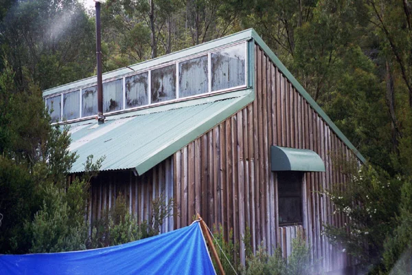
The third Lake Tahune Hut. Built in 2018

Floorplan of the third Lake Tahune Hut
The newest hut at Lake Tahune was opened in April 2018. It is on the site of two earlier huts that had served visitors since 1947. It differs from the traditional Australian approach to remote hut design in many ways and it will probably continue to influence huts long after the shine on the walls has been replaced with the grime left behind by thousands of visitors.
As the floor plan shows, a living room takes up half the hut with a bunk room, a rangers room and a partially enclosed porch accounting for the rest. There are bunks at either end of the living room, an alcove at the centre of the main room with more bunks and benches under the window that can be utilised for sleeping, giving a total capacity of 24 (plus anyone in the rangers room).

Exterior of the third hut at Lake Tahune. Built 2018. Photo from Valley Workshop website.
The well insulated hut has a hardwood floor, triple glazed windows and is lined with plywood and decorated with 1980s style inspirational quotes painted on the walls. However what most distinguishes the hut from any other remote hut in Australia is that it has lighting, heating and USB recharge ports powered by a small hydro electric turbine. The hut was designed by Hobart architects Green Design (who also did the plan for the 2018 replacement of Sitzmark Lodge at Mt Mawson club ski field). The $450,000 contract to build the new hut and nearby toilet went to the northern Tasmanian builder Valley Workshop. After prefabricated sections were helicoptered to the site, construction took five days and the hut was complete in April 2018
While there have been a few new huts built on the Overland Track this century, they were designed for mass tourism. In Victoria replacement huts in the original style have been built after huts such as Ropers and Westons were consumed in bushfires. But the new Tahune Hut is the first new design of a remote mountain hut since Federation and Michell huts were built on Victoria's two highest mountains in 2005. Those huts included a non traditional internal design and one included a rangers room, but they did not include bunks and the exteriors had a fairly traditional corrugated iron cladding. The new Tahune hut is much larger and is designed for visitors to sleep inside rather than in tents. The provision of electric heating eliminated the need for a heating stove and permitted large windows to be installed.

Interior of the third Lake Tahune hut built in 2018. Photo from Valley Workshop website.
Background
In May 2016 the Parks and Wildlife Service announced that the hut at Lake Tahune beneath Frenchman's Cap would be replaced. This was the final stage of ten year long project to upgrade the track and facilities on the main approach to the mountain from the north. Much of the funding was provided by the philanthropist Dick Smith. Over a decade Smith donated $100,000 each year to the project and the Tasmanian government gave $50,000.
In November 2016 the PWS announced that a new hut was planned and stated 'The new hut will double the sleeping capacity at the site, providing accommodation for 24 walkers as well as two rangers. Additional deck area will provide a hardened surface around the hut for seating and cooking.' Rumours suggested that the new hut might have solar panels for lighting and even a micro hydro system for heating, but some commentators thought that was fairly unlikely for a hut in a remote location that would not be heavily used.
After the inevitable complex bureaucratic planning process during which several design proposals were publicly released, construction of the new hut began in early 2018 with building material flown in by helicopter to the helipad that was built circa 1970 for the construction of the second hut.
The second hut had some historical significance, but sadly it was not preserved and used as a rangers hut. Rather it was demolished and the new hut was built on its site.
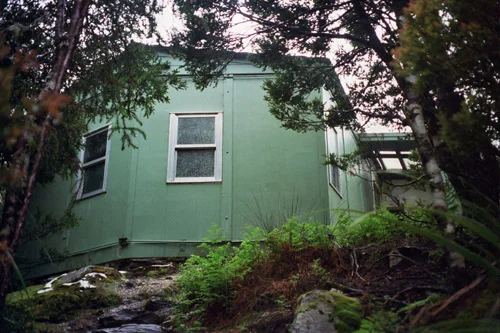
The second Lake Tahune Hut. © David Sisson 2004.
The second hut at Lake Tahune. 1971 - 2018
The second hut at Lake Tahune was built on the site of the original hut in June 1971. The project was overseen by Brian Collin, a Hydro Electric Commission engineer and keen bushwalker.
The prefabricated hut was adapted from an Antarctic design by the Scenery Preservation Board, apparently the unusual six sided shape was to improve it's snow loading strength. The HEC provided transport to the site. Building materials were first taken to Mt McCall by truck and then ferried to Lake Tahune by helicopter. It took Collin and three assistants seven days to erect the hut. The porch was built out of left over timber although it was not in the initial plans. According to PWS, the hut was 'refurbished' in 1994.
Interior of second Lake Tahune Hut, © The Outdoor Diaries 2004. Used with permission.
The hut was originally in the open, overlooking both Lake Tahune and the Franklin valley, but within a few years scrub regrowing after the fires surrounded the hut, making it difficult to photograph.
It was historically significant due to it's adaption from an Antarctic design and because it was one of the first mountain huts to be prefabricated and entirely transported by helicopter. In this respect it was a predecessor to the second Lake Vera Hut and the current Federation and Michell huts on Victoria's two highest mountains.
Visitation to Frenchmans Cap increased greatly after sections of the walking track from the Lyell Highway were rerouted and the rest of the track was substantially improved. As a result, usage of the hut at Lake Tahune also increased and it became increasingly crowded at peak times, so PWS decided to build a new and larger hut. Sadly those involved in the decision to demolish the hut did not consider that it's historic significance was sufficient to preserve it for use as a rangers hut. Instead the hut was demolished and a third hut was built on the same site with a separate rangers room.
Construction
A six sided steel hut with a wooden floor resting on huon pine foundations with a huon pine skillion porch. The hut had two tables, bench seats and four shelf bunks with mattresses, each shelf bunk accommodated four people. The original stove was removed (although scorch marks on the floor showed its former location) and It was replaced by a methylated spirits heater, however metho was rarely provided. In the last decade of the hut's life this inadequate stove was replaced by a briquette heater.
The first hut at Lake Tahune. Photo: Barry Ford, 1957.
A water tank was located on the south western side of the hut. To the north a dunny was perched on the edge of a cliff and an exposed helipad nearby had great views over the Franklin valley. Sheltered campsites were (and still are) located near the helipad and south east of the hut overlooking the lake.
The first hut at Lake Tahune. 1947 - 1966
In 1940 Ray Livingston lobbied for a hut to be built at Lake Tahune, but wartime shortages and his death in 1943 meant that nothing happened until after the war.
Frank Hurley's photo of Lake Tahune in 1947. Lions Head towers above the lake while the face of Frenchmans Cap is to the left of this scene. Source: National Library of Australia.
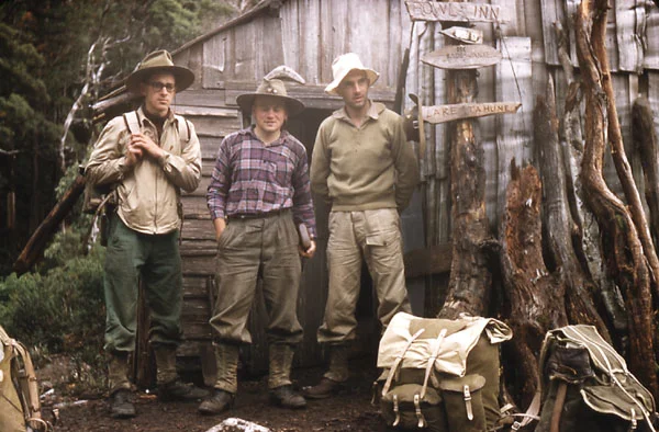
Jack Thwaites had continued to lobby for the hut and the Scenery Preservation Board commissioned Cliff (an apt name for the location) Bradshaw to build the hut. Bradshaw was a West Coast timber worker and former miner who had climbed the mountain from the west with Fred Smithies in 1931 attempting to follow an overgrown track from Crotty near Queenstown, so he was fully aware of the difficulties the mountain presented.
Bradshaw was assisted by mill hands and his sons Bernie and Henry. The hut was mostly built in 1946 and completed in January 1947 after a bumper snow season had broken the huts ridge pole.
The Bradshaws had tried to carry a 1.8 metre long crosscut saw along the overgrown track but soon abandoned it and instead built the hut from palings split on site from the only suitable species of tree, King Billy pine. Bernie recalled that they made a number of trips to the site but 'were chased out by the weather a couple of times, snowflakes were coming down like dinner plates. It was quite a good hut actually. The palings fitted up pretty well and it was a reasonable size.'
Frank Hurley, legendary photographer of Sir Ernest Shackleton's 1914 - 1916 Endurance expedition was less charitable when he visited in Easter 1947. 'Only an average job roof timbers had warped considerably, leaving cracks rendering the hut far from weatherproof'.
However the dirt floored hut endured and gave reasonable shelter until it was destroyed by a bushfire in November 1966 that also killed many of the King Billy pines in the area.

Detail of the original Tahune Hut among King Billy pines from Hurley's 1947 photo.
References
The following sources were used:
John Chapman. South west Tasmania: a Guidebook for Bushwalkers. 4th ed. John Chapman, 1998.
Simon Kleinig. 55 years at Tahune Hut. pp 95 - 99, Tasmanian Tramp. No 34. 2002.
Simon Kleinig. Frenchmans Cap: the story of a mountain. Glass House Books, 2012.
Simon Kleinig. Journeys to the Ivory Tower: in the footsteps of the pioneers. pp. 28 - 31 in Wild No. 77. Winter 2000.
Phil Robinson. A climbers guide to Frenchman's Cap NP, 1979. pp. 9, 11.
John Siseman & John Chapman. Cradle Mountain National Park: Frenchmans Cap - Walls of Jerusalem. [1st ed.] Algona, 1979. pp. 106 - 115.
Tasmanian Parks and Wildlife Service. Frenchmans Cap... draft recreation zone plan. 2018.
The hut is also mentioned in occasional issues of the Tasmanian Tramp, Skyline, Outdoor Australia and Wild.
Lake Vera Hut. ©. David Sisson, 2004.
Lake Vera Huts
Also known as Michael's Hut. © David Sisson, 2005, 2015, 2018.
Located 100 metres east of Lake Vera, 50 metres north east of the Vera Creek bridge on the walking track to Frenchman's Cap. The hut is at an altitude of 555 metres. Grid: 079 194. What3words ///sponge.slanting.edible
History
The lake was named in 1910 by the track cutter and writer J. E. (Ernie) Philp after his wife. The first hut was built by a lakeside swamp in June 1962 and was reroofed in the late 1960s. It was a slab hut with a split paling floor and was slowly disintegrating by the late 1970s. The original hut was reputedly dismantled in the early 1980s.
Interior of Lake Vera Hut looking from shelf bunks towards the cooking and seating area. © The Outdoor Diaries 2004. Used with permission.
Work on the present hut began in November 1978 and was completed in March 1979. It remains in good condition. The 2018 management plan noted that due to increasing use authorities should "consider the future need for an expansion of the structure (a second room on the north end is likely most practical)... A new north-facing wing would likely require a re-think of the internal layout of the hut, perhaps locating cooking/living areas in the new northern wing. The potential for separate staff accommodation should be considered..."
Just off the track, north west of Barron Pass, is a memorial to the prominent landscape and poster artist Harry Kelly who helped pioneer the route in the years before the Second World War.
Construction
A comfortable and fairly large hut with a practical layout. Clad in timber, the hut has a wooden floor and a corrugated iron roof. One end of the hut contains benches, stainless steel covered tables and a coal stove.
Four shelf bunks that each sleep four or five people are at the other end of the hut with room for an extra person under the roofline above the veranda. Outside are coal bins, a water tank and a helipad.
Until 2016 the only practical campsites were behind the hut and next to the helipad, however several tent platform have now been built and more are planned. There is a small paling jetty 20 metres from the hut on Vera Creek, although it is frequently under water. The dunny is located 100 metres south of the hut along the main track to the Lyell Highway, although this is scheduled for replacement at a new location closer to the hut around 2020.
References
John Chapman. South west Tasmania: a Guidebook for Bushwalkers. 4th ed. John Chapman, 1998.
Rowland Kelly - interview, 2005.
Simon Kleinig. Frenchmans Cap: the story of a mountain. Glass House Books, 2012.
Simon Kleinig. Journeys to the Ivory Tower: in the footsteps of the pioneers. pp. 28 - 31 in Wild No. 77. Winter 2000.
Phil Robinson. A climbers guide to Frenchman's Cap NP, 1979. pp. 9, 11.
John Siseman & John Chapman. Cradle Mountain National Park: Frenchmans Cap - Walls of Jerusalem. [1st ed.] Algona, 1979. pp. 106 - 115.
Tasmanian Parks and Wildlife Service. Frenchmans Cap... draft recreation zone plan. 2018.
The hut is also mentioned in occasional issues of the Tasmanian Tramp, Skyline, Outdoor Australia and Wild.
Other huts at Frenchmans Cap
In the mid to late 1930s there was a minor gold rush to the Jane River. In addition to the miners huts there were several staging huts half way between the road and the goldfield on the Loddon Plains. On occasions walkers headed for Frenchmans Cap sheltered in these huts. After the Second World War the goldfield was worked sporadically, never by more than a few people at a time, before mining finally ceased around 1990?

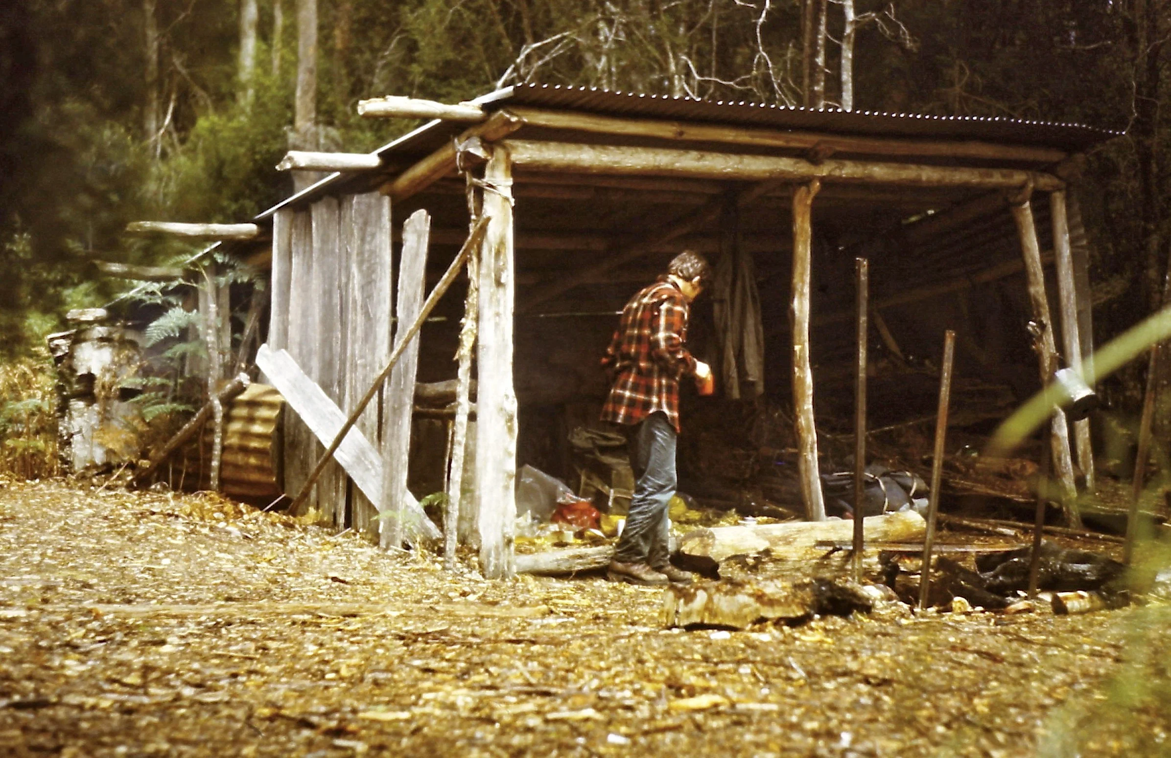
Junction Creek shelter in 1975. © David Noble from his 23 day walk in S.W. Tas album.
Three sided shelters
This section is under development and not yet complete. If you can help with any extra information it will be gratefully acknowledged. Please send it to: australianmountains (at) gmail.com. June 2018, revised Sept 2018, Feb 2021.
There were once at least seven, three sided huts in the south west. These shelters often provided the only cover for several days walk in any direction and they were a welcome respite from the unrelenting wind and rain of the south west.
Locations of all seven known three sided shelters.
Four of the shelters were built in about 1960 by the state government and sadly all of these been removed by 1998. The government shelters appear to have been built to the same very basic design with dirt floors and one side open to the weather. They had no fittings or furniture although it is possible that one had a bunk bed.
The larger Blakes Opening shelter. Wikimedia commons photo by Raki_Man. (I've been unable to trace the person who took this public domain pic, but would like to give an attribution if possible.)
At least two shelters were built of corrugated iron supported on bush poles on the banks of the Huon River. So far I have been unable to discover their provenance. Finally there is a remote shelter on Bond Bay in the northern part of Port Davey.
The four government sponsored shelters were removed due to environmental concerns and because it was felt they intruded into the wilderness value of the south west. The two shelters on the Huon River appear to have been left alone and allowed to collapse from natural decay and the Bond Bay shelter (probably) remains intact.
This is a long term project and information on these shelters is very sparse, so researching them will be slow. If you know where other shelters were or can help with photos, information or anecdotes related to anything about them, please send it to australianmountains (at) gmail.com. Thanks.
There were at least seven shelters. Known locations are:
The small Blakes Opening Shelter Dec 2008. Photo © Luca Zucchi from Eastern Arthurs album at RetiredAussies.com (Used with permission.)
Blakes Opening. On the Huon River north of Mt Picton. There appear to have been two incarnations of this shelter, Judging from photos and an email from a veteran bushwalker, the first was about 4 metres square, over two metres high with a large log at the back and sides made from split slabs. Photos from early this century show a much smaller 2 metre wide structure with corrugated iron sides and a 1.4 metre high roof supported by poles. At this stage my guess is that the second shelter was built with material salvaged from the ruin of the first. This smaller shelter was still standing in 2009 but had totally collapsed by 2015. (Link to photo.)
Bond Bay. There is a small shelter with a roof and two walls at Bond Bay on Port Davey. It is not near any walking route and is only visited by yachties and kayakers as the roof is used to collect fresh water. Page 65 of the PWS management plan states it was built in the early 1990s using material from the abandoned Claytons House which was located 250 metres to the north. Link to a photo.
Bond Bay shelter. Photo by Matt at on his West Coast kayak blog.
Cracroft Crossing. A government sponsored shelter identical to the one at Junction Creek. The valley is vulnerable to flooding and even though the shelter was around 150 metres from the river and on a slight rise. In winter 1993 a group was trapped by floods and had to spend a night on the roof. At a minimum the shelter existed from Nov 1968 to Feb 1995 as log books from that period are preserved.

Cracroft Crossing shelter from John Chapman, South West Tasmania. 1st ed., 1978. Used with authors permission.

Interior of Junction Creek Shelter 1976. © David Noble from his Winter traverse, Western Arthur Range album. Used with permission.
Deadmans Bay a government shelter on the South Coast Track at Little Deadmans Bay. Probably built circa 1960, but at a minimum existed from Nov 77 to Feb 82 as log books from that time are preserved.
Farrell Point on the Bathurst Harbour narrows. A shelter of the standard government design apparently built by the track cutter Milford Fletcher. Probably existed from the early 1960s to mid 1990s.
Harrisons Opening. A basic shelter on the lower Huon River built from corrugated iron supported on bush poles. Collapsed early this century.
Junction Creek. On the Arthur Plains circa 400 metres south west of the present campsite beside the creek. The government shelter was probably removed in 1991, log books survive from January 1974 to April 1990.
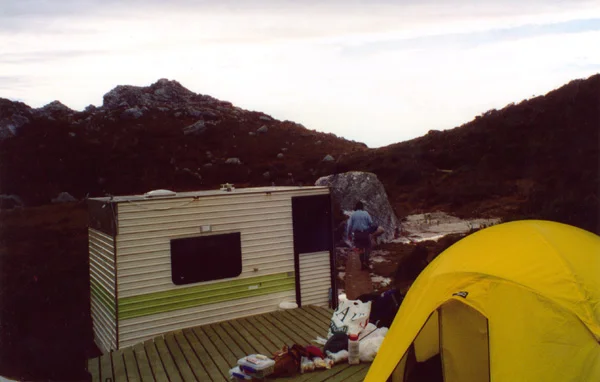
The hut at High Moor, Western Arthur Range. © 2003. Simon Walliss and David Sisson
Transportable track builders hut
David Sisson. 2005, updated 2015.
The hut was transported by helicopter to remote sites in western Tasmania and used for accommodation and storage by track building teams around the turn of this century. Despite its modest size, the hut was well designed and had two beds, a table, sink and storage cupboard.
The photo was taken at High Moor on the Western Arthur Range, but what appears to have been the same hut was spotted at other locations including the Ironbound Range on the South Coast Track.
Why track builders and their hut were needed
By the 1970s new hydro and logging roads provided easier access to many areas in the south and west of the state that had previously required a walk of several weeks. Hikers became more interested in these areas and foot pads started to form across several mountain ranges in southern and western Tasmania. As usage increased, guidebooks describing the routes were published which stimulated more interest. The increased traffic began to cause erosion in soils that were often only glacial silt, so there was a need for proper tracks and tent platforms to be built. Many places such as High Moor are still at least a three day walk from the nearest road head, so track builders and their equipment were transported to work sites by helicopter and this hut was used to provide basic shelter and amenity for them.